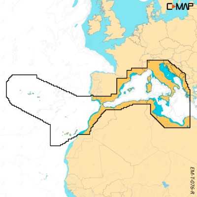

Simrad C-MAP Reveal X M-EM-T-076-R-MS West Mediterranean Chart for NSX 64220703
Simrad C-MAP Reveal X M-EM-T-076-R-MS Next Generation West Mediterranean, Azores, Canary Chart with game-changing Shaded Relief for NSX Simrad Smart Chartplotters.
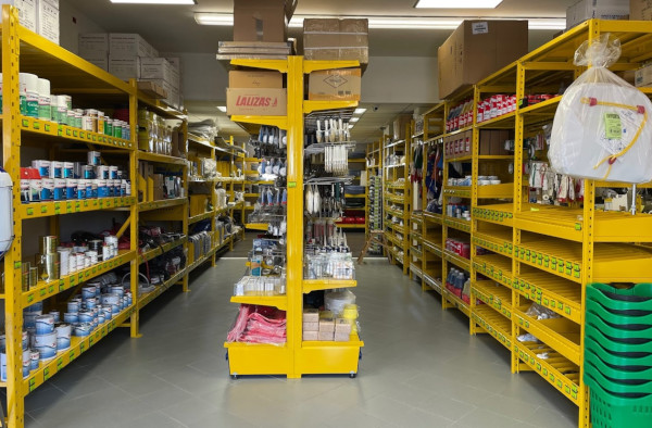
Visit us in our shop
WE ARE AT YOUR DISPOSAL AT OUR POINT OF SALE
Not just online! Come and visit us also in the shop!
In our store you will find a wide selection of selected items and you will be assisted by our specialized staff with over a decade of experience in the nautical sector.
Everything for the boat ... deck equipment, anchoring and mooring, hydraulic and electrical systems, photovoltaics, stainless steel hardware, antifouling and paints, engine spare parts, on-board safety, sailing accessories, nautical instruments, GPS, depth sounders and much more!
We are in San Giorgio di Nogaro in the province of Udine, an important basin, located in the Bassa Friulana, bathed by the Corno river ... a few km from well-known destinations such as Lignano, Grado, Trieste etc.
Nautimarket Europe s.r.l., Via Marittima 17, 33058 San Giorgio di Nogaro (UD) Italy

(modificale nel modulo Rassicurazioni cliente)

(modificale nel modulo Rassicurazioni cliente)

(modificale nel modulo Rassicurazioni cliente)
Simrad C-MAP Reveal X M-EM-T-076-R-MS Next Generation West Mediterranean, Azores, Canary Chart for NSX Simrad Smart Chartplotters
Experience the X generation of C-MAP charts – with game-changing Shaded Relief!
C-MAP® REVEAL™ X offers a fresh, dynamic experience. All the great features from DISCOVER X, including all-new Map Inspector Tool, and more – bring the world around you to life with Shaded Relief and feel connected to your surroundings with Satellite Overlay. REVEAL X charts also deliver smooth integration with the Simrad® Companion App and come with 12 months free online updates.
Exclusively for Simrad® NSX.
Main Features:
• Next Generation Charts
• Smooth App Integration
• NEW Map Inspector Tool
• Full-Featured Vector Charts
• Hi-Res Bathymetry
• Custom Depth Shading
• Best-in-Class Day & Night Modes
• Tides & Currents
• Detailed Marina Port Plans
• Harbor & Approach Details
• Subscription-Free Autorouting
• 12 Months Free, Easy Updates
• Connected Experience – Future-Proof
• Satellite Imagery
• Shaded Relief REVEAL Layer
Next Generation Charts
A fresh, dynamic chart experience, making navigation clearer than ever before
• Optimised data and new chart presentation to give you the best on-the-water navigation experience
• Always see the data you need without clutter, optimised at every zoom level
• Best-in-class Day & Night modes. Stay safe and navigate with ease, whatever the weather, whatever the time of day
Smooth App Integration
Link to the Simrad® Companion App – enjoy the same charts and a fully connected experience
• Plan trips, review tracks and plot waypoints on the App, then sync straight to your NSX
• Access NSX manuals, “How To” guides and much more, directly from the App
• The future is connected; with C-MAP & Simrad, you’ll be ready
The Best of C-MAP
The latest chart data, with the detail you need to make the most of your time on the water
• Full-Featured Vector Charts – make navigation easy with accurate, up-to-date vector chart detail from official hydrographic office sources
• High-Res Bathymetry – identify shallows, drop offs, ledges, holes or humps, with accurate contours down to 1-foot. Includes the best of C-MAP HRB data
• Subscription-Free Autorouting – Automatically plot the shortest, safest route based on detailed chart data and your vessel information. With C-MAP, Easy Routing is always subscription free
• Custom Depth Shading – set a clear visual safety depth or create your own shading and level-up your fishing to see things your way
• Harbor & Approach Details – approach any harbor and inlet with confidence. The perfect conclusion to a long cruise or an exciting day of fishing
Exclusively in REVEAL X:
• Shaded Relief – bring the world around you to life with 3D rendered land and underwater elevation, including areas of ultra-high resolution – a game-changer for anglers and divers
• Satellite Overlay – feel better connected to your surroundings when you find yourself in an unfamiliar place
New Map Inspector Tool
Quickly access the information you need, with a simple touch of the screen
• Tides & Currents – detailed projections of water level and tidal data to help you plan your day out
• Detailed Marina Port Plans – docking in an unfamiliar port is no problem when you have precise layouts of thousands of marinas, including slip spaces, restricted areas, and other vital information
12 Months Free Chart Updates