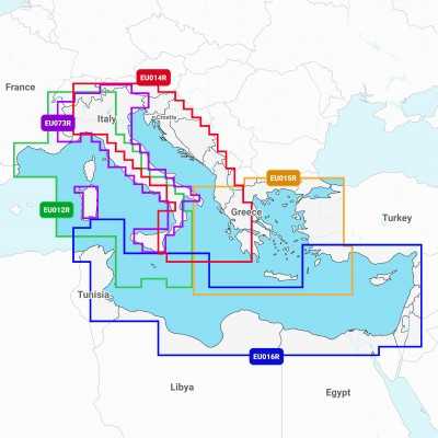


Navionics+ Small 2 Cartography SD MICROSD Zone Maps 61920552MSD
Navionics+ Small 2 Cartography SD MICROSD offers greatest detail on seas and lakes for going out with your motor boat, going fishing or sailing. You will have the most accurate navigation details on your GPS plotter.
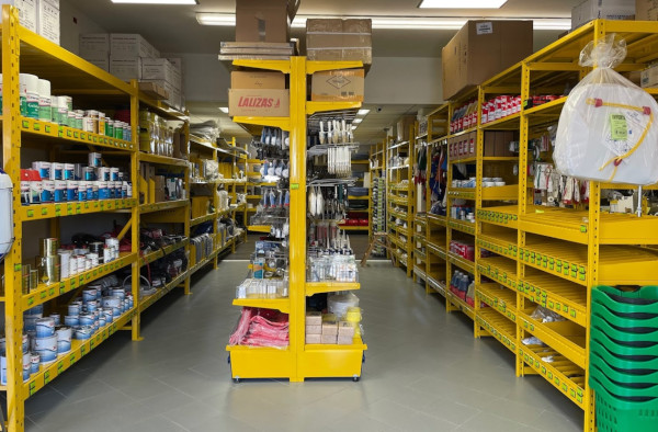
Visit us in our shop
WE ARE AT YOUR DISPOSAL AT OUR POINT OF SALE
Not just online! Come and visit us also in the shop!
In our store you will find a wide selection of selected items and you will be assisted by our specialized staff with over a decade of experience in the nautical sector.
Everything for the boat ... deck equipment, anchoring and mooring, hydraulic and electrical systems, photovoltaics, stainless steel hardware, antifouling and paints, engine spare parts, on-board safety, sailing accessories, nautical instruments, GPS, depth sounders and much more!
We are in San Giorgio di Nogaro in the province of Udine, an important basin, located in the Bassa Friulana, bathed by the Corno river ... a few km from well-known destinations such as Lignano, Grado, Trieste etc.
Nautimarket Europe s.r.l., Via Marittima 17, 33058 San Giorgio di Nogaro (UD) Italy

(modificale nel modulo Rassicurazioni cliente)

(modificale nel modulo Rassicurazioni cliente)

(modificale nel modulo Rassicurazioni cliente)
NOTE: SPECIFY IN THE ORDER NOTES THE AREA OF INTEREST.
Navionics+ Small 2 Cartography SD MICROSD
Navionics+ Small 2 is the most popular chart with boaters and fishermen all over the world, offering the largest coverage areas along with the absolute best detail. A Gold chart can seamlessly cover an entire continent and yet be able to zoom down to a resolution of 1 meter (3ft), with an abundance of data derived from the best available sources and augmented with Navionics' own surveys and the Community Edits. Features include a clear, easy to use, familiar paper-like display of all detail available from the best nautical charts.
Plus:
- Tides & currents.
- Port plans.
- User-selectable safety depth contour.
- Marine services with phone numbers.
- Navigation aids with XPlain.
- Marsh areas.